| Home | > | List of locations | > | Chakwenga Headwaters and the Nyabutaye Peat Bog |
Location: Chakwenga Headwaters and the Nyabutaye Peat Bog
Photo: Mike Bingham
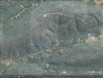
The Chakwenga Headwaters. The Chakwenga arises in the dambo at the bottom left of the photograph (B), and flows eastward before turning south towards its confluence with the Zambezi. A winding track leads to transmitting towers at the crest of the hill. The Nyabutaye (A) is a short tributary of the Chakwenga.
Photo: Mike Bingham
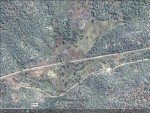
The Nyabutaye Dambo. The former alignment of the Great East Road crossed the Nyabutaye at its outlet from the dambo (at the 1070m altitude marker). The current alignment cuts the dambo roughly in half. The peat bog occupies most of the open terrain to the north of the road, and is flanked by two semi-permanent streams.
Photo: Mike Bingham
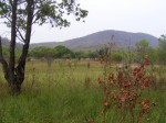
Scorched Syzygium cordatum, the grass Imperata cylindrica (white) and the fern Thelypteris confluens.
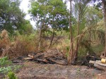
Photo: Mike Bingham
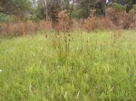
Forest clearing. The soft wood of the forest tree is unsuitable for making charcoal by the tradition method – these logs will simply be burned.
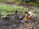
Photo: Mike Bingham
The water is clear and stained brown by tannin secreted by the vegetation. Such ‘black water’ is sterile, almost devoid of nutrients and animal life.
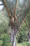
Photo: Annette Willemen
One of the Raffia palms Raphia farinifera along the road that mark the Nyabutaye dambo.
General Information
Quarter degree square: 1529A2 Country: Zambia Habitat: Peat bog Altitude range: 1070-1150 Annual rainfall: 900 - 1000 Location (short): A gorge cut into the hill range on the north side of the Great East road drains into a peat bog which is the source of the Nyabutaye, a short tributary of the Chakwenga, which has its source about 1 km to the west. Location (detailed): Before Zambia went decimal the 80-mile milestone on the Great East Road marked a feature which nature enthusiasts coined the 80-Mile Dambo. A gorge cut into the hill range on the north side of the road drains into a peat bog which is the source of the Nyabutaye (Nyautai on the Survey Department maps), a short tributary of the Chakwenga, which has its source about 1 km to the west. From the road the dambo can be recognized by the clumps of raffia palms (Raphia farinifera) with their enormous leaves reaching up into the sky. The peat bog is flanked by streams on the west and east sides. During most of the year much of the area between these streams is awash, the water flowing as a sheet over the surface. The peat is a little more than a meter deep in the deeper parts. A block of gallery forest, with evergreen species, Syzygium cordatum, Vitex doniana and Gardenia imperialis, occupies the upper part of the western stream. |
Description
Flora: Edward Robinson, who was employed as a teacher and later as an inspector of schools from 1952-1966, was a prolific botanical collector who made a comprehensive collection of the flora of the Chakwenga Headwaters on numerous visits between August 1963 and March 1965. Robinson focused on the herbaceous component, omitting the better known woody flora, but he collected in the woodlands as well as in the wetlands.Other notable collectors include Arne Strid, 1972; Graham Williamson, author of The Orchids of South Central Africa, J.M. Dent & Sons, 1977; and Jan Kornaś, a fern specialist.
References and further reading:
The Chakwenga Headwaters and the Nyabutaye Peat Bog
M.G. Bingham, 2002. Edward Robinson’s contribution to Zambian botany. Kirkia Vol. 18, Part 1, 11-15.
M.G. Bingham, 2007. The Raffia Palm, Black Lechwe Vol. 15, No. 2
M.J. McFarlane, 1995. Pans and dambos of Western Province, Zambia. - A preliminary consideration of their geomorphology /hydrology. Report on a backstopping mission to the Land and Water Management Project, Dept. of Agriculture, Mongu, Zambia.
G. Williamson, The Orchids of South Central Africa, J.M. Dent & Sons, 1977.
Useful links
View a list of records for Chakwenga Headwaters and the Nyabutaye Peat Bog
View a list of recorders who have visited this location
| Home | > | List of locations | > | Chakwenga Headwaters and the Nyabutaye Peat Bog |
