| Home | > | List of locations | > | Gonarezhou National Park |
Location: Gonarezhou National Park
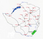
Photo: Bart Wursten
Map showin location of Gonarhezou National Park
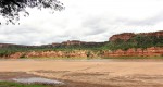
Photo: Bart Wursten
Chilojo Cliffs, one of the major features in Gonarhezou.
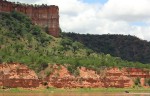
Photo: Bart Wursten
Elephant crossing Runde River below Chilojo Cliffs
General Information
Quarter degree square: Country: Zimbabwe Habitat: Altitude range: Annual rainfall: Location (short): Location (detailed): This park in the remote southeasten low-veld is the second largest in Zimbabwe after Hwange National Park. It covers an area of more than 5,000 km² in Chiredzi district, Masvingo, bordering on Mozambique in the Southeast. The park is managed by the Zimbabwean Department of National Parks and Wildlife Management. |
Description
Useful links
View a list of records for Gonarezhou National Park
View a list of unique taxa (excluding cultivated plants) for Gonarezhou National Park
View a list of unique taxa (all taxa whether cultivated or not) for Gonarezhou National Park
View a list of recorders who have visited this location
| Home | > | List of locations | > | Gonarezhou National Park |